- Conservation
Explore our birding-specific websites:
- Education
- Policy
- Lands
- Centers and EventsCentersEvents
- About Us

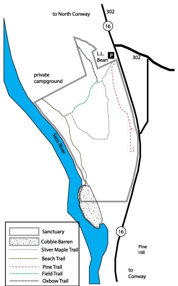
MAIN TRAILHEAD is located next to the LL Bean parking lot at the junction of Rts. 16 & 302.
Another access point is from the privately-owned Saco River Campground.
PINE TRAIL – Red Markers
1/2 mile, one-way; about 25 minutes round-trip
An easy walk that features three pine species and sits atop an esker (glacial feature)
SILVER MAPLE/FIELD TRAIL LOOP – Yellow Markers
1 Mile loop, about 1 hour round-trip
A level loop hike that winds through restored and historic floodplain forests and a variety of field habitats. Begins from the main trailhead.
BEACH TRAIL – Yellow Markers
1/2 mile, one-way; about 25 minutes round-trip
Runs from the campground to a riverine cobble barren with rare plant populations. Please stay on the trail!
From the trailhead, follow the woods roads downhill through the woods to a trail junction. A segment of the trail ends at an open cobble barren along the river with beautiful views of the region. Waterbird species such as spotted sandpiper, belted kingfisher, and common merganser can be found here during the breeding season. Only the upstream portion of the barren is owned by NH Audubon; the rest is owned by the Town of North Conway.
An example of the globally-rare hudsonia – silverling river channel community occurs along the upper portion of the cobble barren at the edge of the forest, where it forms a narrow strip of vegetation on the channel shelf above the river. Grasses, forbs, mosses, and lichens are the dominant life forms, although vegetation is sparse overall. Widely scattered shrubs and saplings are also present. The substrate on the surface ranges from a thin layer of nearly pure sand to a mixture of sand, gravel, and small cobbles that have been deposited by the Saco River.
Two state-threatened plants occur in this community, hairy hudsonia (Hudsonia tomentosa) and silverling (Paronychia argyrocoma). There are over three hundred patches of silverling on the Audubon portion of the cobble barren. These patches range in size from a single stem to 3 square feet. The hairy hudsonia is less common here, occurring in scattered clumps that total only about 4 square feet of cover. Hairy hudsonia is most frequently associated with the sandier zones found near the highest areas of the channel, which are often farthest from the river itself. The distribution of silverling is similar, but it extends further out onto the cobble.
Besides the hudsonia and silverling, other characteristic plant species here include little bluestem, early goldemod, Rand’s goldenrod, biennial evening primrose, jointweed, panic grass, and intermediate pinweed. Sand sometimes forms low, tear-shaped mounds behind vegetation clumps. These mounds are aligned with stream flow direction, and are the result of deposition in lower velocity eddies behind the plants.
This natural community is currently known only from river channel barrens along the Saco River in New Hampshire and Maine. Its restricted distribution likely corresponds to a combination of flood-related disturbance and soil conditions along the river profile. Above open cobble shores, river channel barren zones are scoured enough to prevent most woody plant growth, but stable enough for perennial species such as hairy hudsonia and silverling to survive and sometimes thrive. Still higher is a sandy environment that is heavily vegetated by shrubs, saplings, and a variety of grasses and forbs. At this height in the channel, floodwater velocities slow to the point where depositional processes outpace erosion. The forested floodplain occurs above this zone.
Backtracking to the trail junction across the stream bed, a loop trail leads to the right around a field edge that is being managed for early successional habitat. Nest boxes here are used by Eastern bluebirds, tree swallows, house wrens, and black-capped chickadees, and many species of wildlife depend upon the young forest habitat for food and cover. Continuing around the field, you will reach a silver maple – false nettle – sensitive fern floodplain forest, a dynamic natural community that in New Hampshire is primarily associated with large and medium-sized rivers affected by periodic and temporary flooding. At the Dahl Sanctuary, the canopy is dominated by silver maple, which forms a tall, arching, cathedral-like ceiling above the level floodplain adjacent to the river channel. Other trees such as American elm, sugar maple, white ash, and basswood also occur as associates. Barred owl and red-shouldered hawk both make their nests in this canopy, and floodplain specialist songbird species can be found here during the breeding season.
The understory is distinguished by a diverse and variable suite of herbaceous plants including an abundance of sensitive fem and false nettle. Other species present in the herb layer include drooping woodreed, drooping sedge, wild sarsaparilla, wood nettle, Canada mayflower, northern short husk grass, sessile-leaved bellwort, hairy Solomon’s seal, inflated sedge, ostrich fem, white baneberry, red baneberry, large enchanter’s nightshade, wakerobin, tall meadow-rue, and northern lady fem. Shrubs and understory trees are more common at the edges and in canopy gaps and include ironwood, choke cherry, mountain holly, red elderberry, meadowsweet, dwarf raspberry, Virginia creeper, maple- leaved viburnum, poison ivy, and partridgeberry.
There is a high degree of microtopographic variation on the ground within the floodplain forest community, with sand deposits, riparian vernal pools, old oxbows, and flood channels occurring throughout, allowing for a high diversity of plant life and wildlife. Evidence of denning mammals, nesting birds, and breeding amphibians can often be found throughout the floodplain forest understory. Return to the parking area by way of the loop trail, which c01mects back with the old woods road. From here, you can explore some of the other side trails within the sanctuary. Of particular interest is corridor extending to the Pine Trail (which permits snowmobile access in winter), a short spur trail dominated by a second- growth upland forest bordering Route 16.
SPRING
SUMMER
AUTUMN
WINTER
Birding NH Audubon’s Dahl Wildlife Sanctuary
by Charlie Nims and Phil Brown
This article first appeared in the Fall 2018 issue of New Hampshire Bird Records.
Download a pdf version of the article.
While the Mount Washington Valley is not often thought of as a birding destination but rather as a destination for families, outlet shoppers, river tubers, hikers and skiers, there is some good birding to be experienced if you do visit the area. The birding crown jewel of the Mt. Washington Valley is NH Audubon’s Dahl Wildlife Sanctuary located on the west side of Route 16, just before the LL Bean outlet store as one comes into North Conway from the south.
History and Description
The Dahl Sanctuary was donated to NH Audubon by sisters, Helen and Ruth Dahl, in 1988. Used as farmland throughout the 1800s and early 1900s, the Dahl Sanctuary is now used primarily for open space, low-impact recreation and wildlife habitat.
The property is a compact 60 acres adjacent to the Saco River with a nice mix of habitats including a coniferous forest adjacent to Route 16, a grassland in a varying degree of succession into shrub land, some small oxbows from the Saco and, of course, a stretch of riverside habitat containing tall Silver Maples and associated floodplain forest species, as well as gravel barrens and sandy banks along the immediate river. This varied set of habitats in a small area results in a high variety of bird species. In addition to birds, the Dahl Sanctuary is an excellent place to observe other wildlife including amphibians and mammals, and it is open for public exploration on a year round basis. Several of the natural community types are rare in the state, and two rare plant species occur.
Historically, it appears that the area has been under birded. In the six years since 2013, when several local birders began actively birding the area, the number of species reported to eBird has jumped from 62 to 159. Of course, some of this is a variation on the “Patagonia Roadside Stop” effect as the more an area is birded, the more species tend to be recorded.
Species Highlights
In recent years, there have been some stellar finds at Dahl including Yellow-breasted Chat, Blue-winged Warbler, Louisiana Waterthrush, Connecticut Warbler, Orange-crowned Warbler, Dickcissel and Golden-winged Warbler. In total, 29 warbler species have been seen, several of which breed in the sanctuary.
While the prime time to bird Dahl is from mid-April through early fall, a surprise can turn up at any time of year. In both January 2017 and 2019, flocks of around 100 Bohemian Waxwings were seen and Pine Grosbeaks have appeared on occasion. A Northern Saw-whet Owl once treated two visitors to a rare look as it roosted in a young pine near the trailhead during late fall.
Some of the more common summer residents include Wood Duck, Great Blue Heron, Common Merganser, Broad-winged Hawk, Spotted Sandpiper, American Woodcock, Belted Kingfisher, Red-eyed Vireo, Warbling Vireo, American Crow, Common Raven, Black-capped Chickadee, White-breasted and Red-breasted Nuthatch, American Robin, Tufted Titmouse, Common Yellowthroat, Yellow Warbler, Pine Warbler, Black-and-white Warbler, Chestnut-sided Warbler, American Redstart, Song Sparrow, Swamp Sparrow, Baltimore Oriole, Rose-breasted Grosbeak and American Goldfinch.
Less common, but regular species include Brown Creeper, Black-billed Cuckoo, Alder Flycatcher, Eastern Kingbird, Eastern Wood-Pewee, Great Crested Flycatcher, Brown Thrasher, Indigo Bunting and Purple Finch.
Among the wide diversity of migratory birds recorded are less common northern warbler species such as Mourning, Tennessee, Bay-breasted and Cape May. In addition to the warblers, Blue-headed and Philadelphia Vireos can be present during migration. A few other specialty species of the floodplain forest may be found during migration or breeding season. These include Yellow-billed Cuckoo, Blue-gray Gnatcatcher, and Yellow-throated Vireo, all species near the northern edge of their range. More southern species such as Carolina Wren, Northern Mockingbird, Red-bellied Woodpecker, Willow Flycatcher and Fish Crow have also been recorded in recent years.
How to Bird the Sanctuary
When you park in the lot, pick up a trail map (they are provided in the mailbox) and review the Sanctuary Guidelines posted in the visitor kiosk. You will notice the Pine Trail immediately across the access road from the parking area. It is not usually worthwhile for birding, but a Cooper’s Hawk has nested in pines just a little way up this trail.
A good way to bird the sanctuary is to walk from the parking lot down the gravel access trail to the Silver Maple Loop Trail continuing to where it meets the Beach Trail. After parking, you will walk past a gate and the trailhead kiosk following a gravel access path downhill. At the bottom, continue straight through a gap in a small wooden fence on the Silver Maple Loop Trail which heads toward the Beach Trail.
Depending upon the management cycle, there may be a “forest” of sumac on your left and mixed trees and shrubs on your right. This can be a productive area for a wide variety of species. Shortly ahead, at a gravel “bridge” designed to restore floodplain habitat by allowing water passage, there is a small wetland on your right. Depending upon water levels it may appear to be either a small pond or a swampy area. This area is particularly good for Belted Kingfisher, Warbling Vireo, woodpeckers, Common Yellowthroat and several sparrow species.
Continuing along the Silver Maple Loop Trail, the habitat becomes more open (patches of regenerating forest are mowed every 8-10 years to maintain shrubland habitat) and is good for House Wren, Chestnut-sided Warbler, American Redstart, sparrows, Indigo Bunting and American Goldfinch. Nest boxes have been maintained in the open areas for Tree Swallows and, less often, Eastern Bluebirds, but are more often homes for Black-capped Chickadees and House Wrens. An American Kestrel nest box located in a Butternut tree has not been used to date.
Approaching the more mature forest ahead, you will come to an intersection where the Silver Maple Loop Trail makes a 90-degree turn to the left (while straight ahead is the intersection with the Beach Trail). This has been the premier Dahl hotspot, named the “Magic Corner” by Rick Steber and Will Broussard, two regular Dahl birders. It is here that some of the big rarities for Dahl have been seen including both Golden-winged (female seen 5-12-18; posted on eBird with photos) and Blue-winged Warblers. Later in the summer when the Jewelweed is in blossom, this is a haven for Ruby-throated Hummingbirds. Regardless of whether rarities are found, the area around this trail junction always seems to be active with the best strategy being patience.
After birding this spot, a good option is to walk straight ahead on the Beach Trail toward the Saco River. While an alternative is to go left on the Silver Maple Loop Trail (more below) for the sake of habitat diversity, we recommend continuing straight ahead and on the Beach Trail. After crossing a swale where water may accumulate on either side, continue left on the Beach Trail which follows the edge of the Saco River to the “beach” area, an aptly named section along the river used by bathers and tubers during the summer. This cobble barren is also home to rare and sensitive plant species that are tracked by the State of New Hampshire.
Along this trail, keep an eye and ear open for House Wrens, American Redstarts, Chestnut-sided Warblers, Baltimore Orioles, Scarlet Tanager, and cuckoos, among others. The past two years, there has been a lonesome male Louisiana Waterthrush singing regularly about 50 yards in from the kiosk sign near where the trail enters the “beach.”
Upon reaching the gravel bar, there is usually a nesting colony of Bank Swallows in the eroding bank across the Saco River and it is a good place to wait for a Belted Kingfisher. Bobolinks can be heard, and sometimes seen, in the fields beyond those banks. Spotted Sandpiper, Great Blue Heron and Common Merganser may also put in an appearance as all are regular in this area of the Saco. Keep an eye out for Osprey and Bald Eagle which are regular during migration and may hunt the river during breeding season.
After visiting the beach, you may choose to return to the Magic Corner and turn right, proceeding onto the remainder of the Silver Maple Loop Trail. Along here breeding Chestnut-sided Warblers and American Redstarts can be numerous. This section is also a good place for thrushes with Veery being the most common. Keep your eyes peeled for a Barred or Great Horned Owl, both of which have been documented in the mature silver maples of this forest. In addition, nest boxes in the floodplain forest may attract Hooded Merganser and Wood Duck, as well as an occasional Northern Saw-whet Owl.
When you complete the Silver Maple Loop Trail and return to the gravel access path where you began, instead of heading up hill to the parking area, you may choose to proceed straight ahead on a well marked path. Shortly, you will pass a small retention pond on the left before entering a wooded area. Immediately upon entering that section, there is a short stub trail on the left that leads in about 20 yards to an oxbow pond where there can be duck species, Wood Duck have nested there, as well as herons and Belted Kingfisher. This trail continues into a private campground, so where that is indicated, please turn around and retrace your steps back to the access path leading to the parking area. This section of path can harbor a variety of birds such as breeding Ovenbird and several woodpecker species including Yellow-bellied Sapsucker, and Pileated, Hairy and Downy Woodpeckers. In the fall, this can be a great spot for migrating passerines, especially warblers, as there is a nice stand of birch. In the fall of 2018, just before the entry into the birch section, an Orange-crowned Warbler was spotted on at least two occasions.
Of course, there are lots more birding opportunities in the Mt. Washington Valley (stay tuned for a future issue to learn about several other less-birded locations in this region), but we hope that this gives you a flavor for the birding to be discovered at NH Audubon’s Dahl Wildlife Sanctuary. If you are in the area or headed north of the notches, stop to explore and discover . . . who knows what you might find?!!
Directions to Dahl Wildlife Sanctuary
Coming from the south via Rt. 16, as one enters North Conway, just before Rt. 302 comes in from the right (east), the sanctuary parking is on the west side of Route 16, but holds only 3-4 vehicles. If it is full, some people park in the LL Bean store parking lot, but please be careful not to impact LL Bean clients, especially in the summer. If coming from the south via Rt. 93 you can take the Kancamagus Highway east (Rt. 112) to Rt. 16 and follow the directions above or take Rt. 3 to Rt. 302 east and follow the directions below.
Coming from the north on Rt. 3, at the traffic lights in Twin Mountain, take Rt. 302 (southeast) over Crawford Notch towards North Conway. Rt. 302 will merge with Rt. 16. Go all the way through the Village of North Conway and then keep an eye out for the LL Bean outlet store on your right. The parking lot is just beyond the light on the right. Alternatively you can take Rt. 16 south from Gorham and merge with Rt. 302 south.
Charlie Nims is an experienced birder living in the Mt. Washington Valley and a NH Audubon member who volunteers for the Common Nighthawk Project and contributed to the Olive-sided Flycatcher Survey. He avidly birds the Dahl Sanctuary year round.
Phil Brown is the Director of Land Management for NH Audubon and has been stewarding the Dahl Wildlife Sanctuary since 2004. On his first visit, he discovered a Northern Saw-whet Owl roosting in a pine and he has been in love with this sanctuary ever since.
Considerable bird data was garnered from eBird.org for this article. We would also like to thank Rick Steber and Will Broussard for their contributions.
For more articles on birding place in the state and information on birds and birding in New Hampshire, subscribe to New Hampshire Bird Records.